


MOAB MOUNTAIN BIKE TRAILS
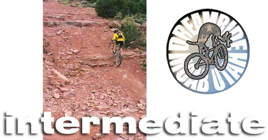
intermediate skill level
An INTERMEDIATE rider is considered to be somewhat experienced and skilled, riding one to three times a week during the biking season over the past two or more years. An intermediate usually rides with clipless pedals and front or full suspension, and can hop a curb with both wheels. Intermediate riders are aware of their equipment, knowing what it means to have a mechanical problem far from civilization. If you shift gears under pressure (hear that loud "poink") you are not an intermediate. If you consistantly break stuff on your bike or cannot fix a flat, a broken chain or cable, then you are not an intermediate. You may be skilled enough to just ride along at an intermediate level, but don't carry enough water or tools, you are not truly intermediate. Knowledge and experience produce intermediate skills. An intermediate rider is aware of hydration concerns and mountain bike safety through experience and study, and usually knows his or her limits well enough to ride at a pace that will guarantee completion of an eight hour trek. Intermediates, while not necessarily fit to the point of being considered athletic, are capable of riding most of the trails in the Moab area with the exceptions of those requiring extreme skills and fitness. A (smart) intermediate can ride most Moab trails during the cooler fall and spring months, given the fact that a few will take as long as 8 hours to complete.
Dreamride's best routes are top secret! If you are looking for extreme solitude, hardcore riding, pristine environment and rare wildlife viewing, that is what Dreamride specializes in. Listings here are traditional mountain biking areas listed in guidebooks and on maps that can be bought. Our favorite routes are not listed anywhere.
This listing is provided by Dreamride LLC of Moab, highlighting a small sampling of trails offered as part of Moab Vacation Packages. For your information, Dreamride does not list its best permitted trails to keep them as private as we can for our clients. If you are looking for more information on mountain bike trails in the Moab area click on OUTDOOR AMERICA MOAB GUIDEBOOK. Be sure to visit the SAFETY GUIDE before coming to Moab. It could save your life and contains valuable environmental information that is required knowledge for all visitors to canyon country. For information on tour packages and other services offered by Dreamride in Uath, Hawaii, and Colorado click on VACATION CATALOG or CONTACT DREAMRIDE.
ADVANCED | HARDCORE GONZO | SLICKROCK AREAS
HOMEPAGE | VACATION CATALOG

Monitor and Merrimac
This is a place for those who wish to be introduced to sand and slickrock challenges. We can customize your visit here to include just about every challenge Moab has to offer. THIS PLACE IS HEAVEN for intermediates!
Group maximum size: 4 of intermediate skills only!
Surfaces: 4WD track, sand, slickrock, ledges, singletrack.
Distance: 17+ miles
Attractions: Dinosaur bones galore at Mill Canyon; bizzare chert nodules
scattered everywhere; western history; geological spots of interest; slickrock
riding challenges; strange rock formations; wildlife; sand slogging (if
you like that sort of thing--we do); the only dirty petroglyphs around Moab. If your group wants to avoid most of
the sand we can take an out and back route, rather than the loop. THERE ARE LOTS OF OPTIONS OUT HERE, including up to 25 miles of challenging terrain.
The standard M&M route begins with a visit to Mill Canyon dinosaur fossil site, then head straight ahead into Mill Canyon across Courthouse Pasture and out to Monitor Butte. We encircle the Monitor clockwise, then tuck behind Merrimac Butte. We stop at the backside of Merrimac Butte for snacks and slickrock fun, then head to Termination Towers to ride around the slickrock shelf. We will head back to the Mill Canyon Trail then take a spur that carries us out and around unnamed buttes above Courthouse Pasture. We will travel west of Courthouse Rock, visiting the Blue Buffalo rock art site, the head back to the trailhead, stopping to check out the old Thompson-Moab stage coach rest stop and a spot next to a spring where Indians once camped.
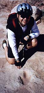
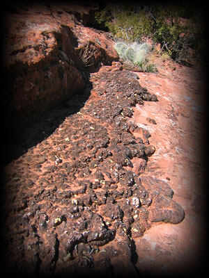
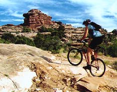
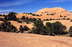
Klondike Bluffs
A popular trail and one of the places we use to evaluate skills at the beginning of any multi-day series, this is true mountainbiking for riders of any skill level and is the best introduction to slickrock skills and Moab terrain. After riding here, you may come upon the realization that you are not an intermediate skill level mountain biker. Advanced riders enjoy this ride as much as children do. The Klondike Bluffs Trail is perfect for your teenage son who fancies himself a racer, if you are worried he might kill himself on the Moab Slickrock Trail, which is certainly possible. This area is known for its dinosaur tracks and fossils as well as deposits of gem stone and, God save us, uranium and copper exploration. The old road now called the Klondike Bluffs Trail follows not only dino tracks, but the tracks of the huge tractor drilling rig that bored out rock samples to hunt for uranium. If you are new to Moab, sample this before you attempt more challenging rides.On a sad note, the dinosaur tracks in the Klondike Bluffs area are being destroyed by people who, with no skill or education, are trying to make molds of the prints to take home. We have seen everything from plaster of paris to spray foam. Needless to say, if people do not know how to make molds safely (using a plastic wrap to protect the track), then they probably should be shot on site before they mess this area up for the true amateur paleontologists. Leaving plaster or plastic stuck to the inside of a track is only one small step away from trying to crack the tracks out of the sandstone. Please do not stand on or mar the tracks in any way.
Group maximum size: 4 or intermediate skllls only! Two groups of four is allowable. Groups of eight are allowed only for private bookings.
Surfaces: Dirt road, technical 4WD track, a bit of single track, sand, and
lots of beginner to intermediate level slickrock and ledges.
Distance: 10 miles +
Attractions: Dinosaur tracks; gemstone; awesome rock formations; historic
mine sites; Indian arrowhead factory; awesome stone bluffs.
A brief pedal in on the wide maintained road takes us alongside the exposed reds and greens (copper and iron deposits) of the Morrison formation to a more technical 4WD track that eventually leads to a dinosaur-tracked slickrock shelf that takes us out to former Indian camp spots and Klondike Bluffs. The trail surface varies from sand to slickrock and all around is scattered Indian-worked chert, agate, dinosaur bone, and gizzard stones (gastroliths). We follow the dinosaur tracks up the slickrock into Arches National Park for a spectacular view of the bluffs. After snacks and a short hike we return to the trailhead. Epic routes are available in the Klondike Bluffs area ONLY THROUGH DREAMRIDE.
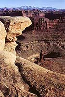
Colorado River Overlook
Awesome ride in the Needles District of Canyonlands National Park. The ride has some great moderate challenges and the destination is very beautiful. Check out the picture. Great fun. Very scenic.
Group maximum: 10 (no mixed skills, unless private group)
Surfaces: Hardpack, sand, and a bit of bedrock on a dirt road.
Distance: 14 miles (out and back)
Attractions: Scenic vistas and overlooks. Some technical challenge, but most of the trail is moderate.
If you want more riding in the Needles District, building this ride into an epic day, we can turn you onto a few other routes out here, but beware that, while there IS a lot of incredible scenery and opportunities for photography and general gawking, there is also a buttload of sand.
Flat Pass
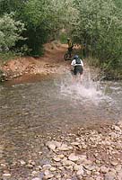 Flat Pass is a challenging ride near Moab that attacks you with bedrock ledges, sand, a generous supply of babyheads and five stream crossings. The ride can include trips to petroglyphs or a swim. Great in the hot summer months! We do it as a one way shuttle and end the ride with a brisk downhill road tour through Moab. Not recommended in cold weather.
Group maximum size: 4 (no mixed skills)
Surfaces: 4WD track, loose rock, hard pack, rocky ledges, stream bed babyheads, deep sand,
slickrock.
Distance: 14 miles.
Attractions: Another classic Moab, Utah ride with stream crossings, red
rock ledges, and box canyons. A fine intermediate ride with technical challenges.
If you choose to do this trail on your own, there is a point on the trail where lots of folks get lost. It also is not a nice place to be when a thunderstorm strikes. Those blackened trees should tell you something.
Arches by Moonlight
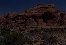 This nighttime road tour of Arches National Park is for the moonlighting
photographer on two wheels. Intermediate to advanced riders who crave something
very unique will be awed by the splendor and haunting beauty of the ride
out to the Devil's garden in spooky moonlight.
This nighttime road tour of Arches National Park is for the moonlighting
photographer on two wheels. Intermediate to advanced riders who crave something
very unique will be awed by the splendor and haunting beauty of the ride
out to the Devil's garden in spooky moonlight.
Group maximum size: 8 (intermediate to advanced only)
Surface: Pavement with options for dirt.
Distance: 25 miles (optional dirt mileage available to groups).
Attractions: Moonlit views of spectacular vistas and strange
rock formations. Nocturnal wildlife. Film and photography instruction by professional photographer.
This is a perfect way to enjoy Arches in the heat of summer--an especially quiet and mysterious way to see the park. THIS IS MAGIC. We have a couple of alternative routes just outside the park that can be enjoyed on the full moon.
Gold Bar Rim
The intermediate route avoids the extreme challenge of this notorious trail by utilizing an out and back rather than a point to point route. The complete trail is not suitable for riders of less than advanced skills, but this route is still challenging enough to put a hurt on your lungs and quads and take you to the very edge of your technical talents.
Group maximum size: 4 (no mixed skills)
Surfaces: 4WD track, ledges, slickrock, sand, loose rock.
Distance: 18 miles
Attractions: Views (awesome view from the rim); Moab-style technical riding
at its best.
This is an out and back ride. From the parking lot on 191 we head toward Gemini Bridges until we reach the Gold Bar Rim turnoff and head south, then east to the Gold Bar Rim. We will stop on the Rim to snack, take in the view, and encourage some slickrock play, then turn around and head out the same way we came in. If the distance turns out to be less than you wanted, we add the highly technical Dog Style route as a finishing touch.
Poison Spider Mesa
We get a lot of business from riders who we find lost on this trail. One of the most popular trails around Moab, Poison Spider Mesa is recommended, but should always be ridden with someone who knows the trail, at least for the first time. Make no mistake the trail is difficult and contains some very challenging slickrock and ledgey dropoffs, but it is appropriate for any intermediate rider or strong and skilled mountain biking family. Remember, if you are walking your mountainbike, it's still mountainbiking. Can be done as an out and back or as the loop described below, ending with the Portal Trail.
Group maximum size: 4 intermediates only.
Surfaces: Technical 4WD track, sand, slickrock, ledges, banked sandy and/or
packed turns.
Distance: 16 miles
Attractions: Sickrock riding at its best! The view of Moab from the head
of the Portal Trail is worth the price of admission. Very many views of
the Portal from shadey spots along the rim.
Poison Spider Mesa to the Portal Trail
Instead of returning via a retrace of the Poison Spider Trail, we will take the Portal downward ONLY IN AN EMERGENCY WEATHER SITUATION. The Portal is ride number 13-- only out of necessity, like lightning. The Portal is not for anyone with vertigo and is just plain dangerous for all, especially if you are stupid enough to ride it. The trail is uncomfortable and dangerous even so when you walk it. We insist everyone walk exposed sections. Poison Spider out and back is the ride we use for intermediates during drooling rain due to the lack of shale sediments on the trail (and the sand is packed in rain).
Group maximum size: 4 intermediates only.
Surfaces: Technical 4WD track, sand, slickrock, ledges, banked sandy and/or
packed turns.
Distance: 16 miles
Attractions: Sickrock riding at its best! The view of Moab from the head
of the Portal Trail is worth the price of admission.
We will travel out to the mesa on a predominately uphill route to the overlook above the Portal Trail, then head downward! Be careful. Once at the bottom of the gravity rush we take Potash Road back to the shuttle at the trailhead.
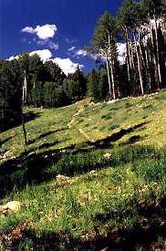
The La Sal and Abajo Mountains
In summer and fall these two mountain ranges, among the three youngest on the planet, are a wildlife delights and lush scenery.
Group maximum size: 4 to 8, depending on environmental sensitivity of trail.
Surfaces: Gravel, hard pack,
stream bed, and sand on 4WD track.
Distances: 5 to 55 mile multi-day camping
Attractions: Abundant wildlife, beautiful views, cool forests, water,
fishing combos.
Trails: Too numerous to mention. For intermediates the prime suggestions are Geyser Pass, Brumley Ridge, Elk Ridge, Beef Basin, Dark Canyon Lake.
In winter and early spring Dreamride offers backcountry ski tours in both ranges and ski/bike combos that include some very nice southern exposure slickrock rides.
"There are trail guides; and then there's the real deal." ~ Bike Magazine
"Mountain Bike America's Moab guide is setting a new standard for guidebooks. Lee Bridgers' first-hand accounts give the reader a sense that they have some behind-the-scenes information about Moab." ~ Brian Fiske, Senior Editor of Mountain Bike Magazine
Lee Bridgers' Moab guidebook is now available in bookstores around the world. Get a signed copy: CONTACT DREAMRIDE.

Call 435-259-6419.
FAX number is 435-259-8196.
or write to:
Dreamride
P.O. Box 1137
Moab, UT 84532